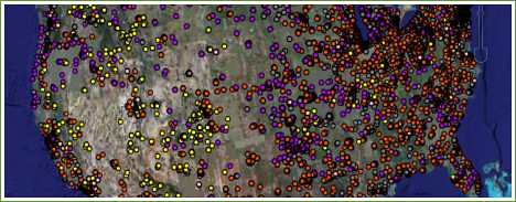
It seems that the Environmental Protection Agency (EPA) has taken advantage of Web 2.0. The agency recently released an interactive site that uses Google Earth as a platform to map out places across the U.S. that have high potential for renewable energy development. The information for this map comes from EPA databases.
The program allows the user to choose from a sidebar list of renewable energy types – various categories of solar, biomass and wind power. When one or several of these categories are checked, the map displays colored dots indicating locations that have shown high potential to produce the indicated type of energy. The dots are different colors depending on if they represent abandoned mine lands, brownfields, RCRA sites or Superfund sites.
Lands that fall into the above categories are potentially contaminated, and are generally unfit for traditional forms of development. In other words, they're not in the highest demand.
Continue at Yahoo! Green